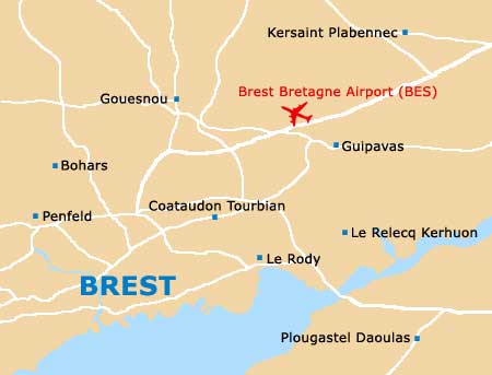
Brest Bretagne Airport (BES)
City Orientation and Maps
(Brest, France)
The city of Brest lies on the southern coastline of France, in the Bretagne region. Famed for its spectacular natural harbour, Brest enjoys a sheltered position and is home to a vast dry dock and the base of the country's Atlantic Fleet. The local ship repair centre is regarded as one of the best in the whole world.
Many people choose to fly into the city each year and Brest Bretagne Airport (BES) is located on the north-eastern outskirts, close to Guipavas. The airport is becoming increasingly popular each year, as more tourists choose to visit this inviting part of France.
Brest Bretagne Airport (BES) Maps: Important City Districts
The city contains two main train stations, the Gare Routière and the Gare SNCF, both are which are located next to each other, on the Place du 19ème-R1, close to the Clémenceau Avenue.
Also nearby in this region of Brest in the tourist information centre, which stands across from the Place de la Liberté and is full of useful leaflets. Around the office you will find a good selection of cheap places to eat, which is worth noting, as most hotels in Brest do not feature their own restaurants.
One of Brest's most impressive landmarks is without doubt the 15th-century castle, located on the headland and boasting superb views of the cityscape. The castle towers feature a number of attractions, including pieces from the Museé National de la Marine.
France Map

Brest Map